
Sichuan and Yunnan Highways to Tibet: Comparing the Most Scenic Routes to Lhasa
Tibet can be reached by flight, train, or road, but the most unforgettable journey is along the Sichuan and Yunnan highways to Tibet. These legendary routes wind through the Hengduan Mountains and into the Kham Tibetan region, where deep gorges, snow-capped passes, turquoise lakes, and prayer-flag-lined plateaus lead all the way to Lhasa, Tibet’s sacred capital.
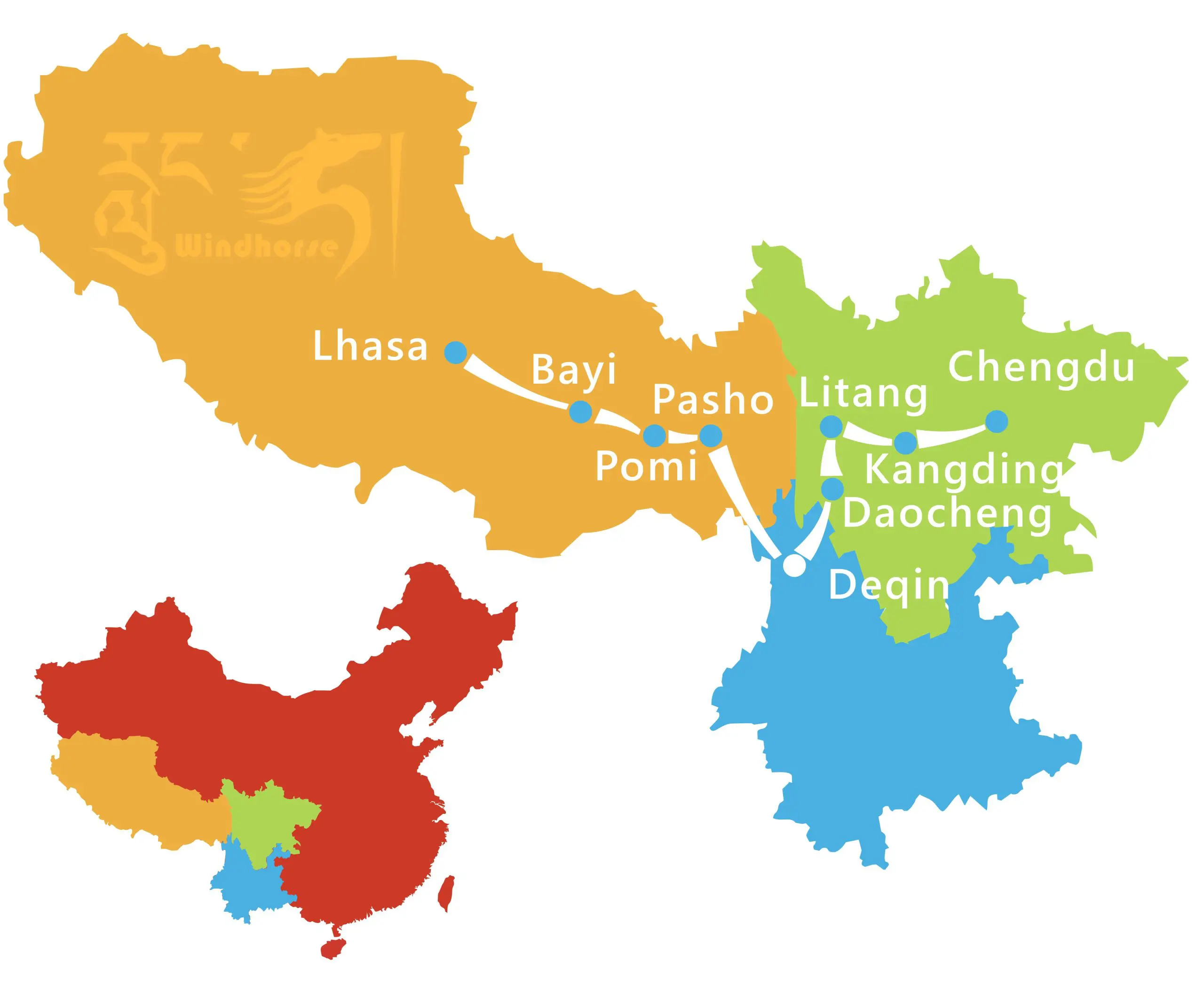
Together, the Sichuan–Tibet Highways (G317 & G318) and the Yunnan–Tibet Highway (G214 + G318) form the three most scenic overland routes from southwest China to Tibet. This guide compares their highlights, landscapes, road conditions, and travel experiences to help you choose the perfect route for your journey to the Roof of the World.
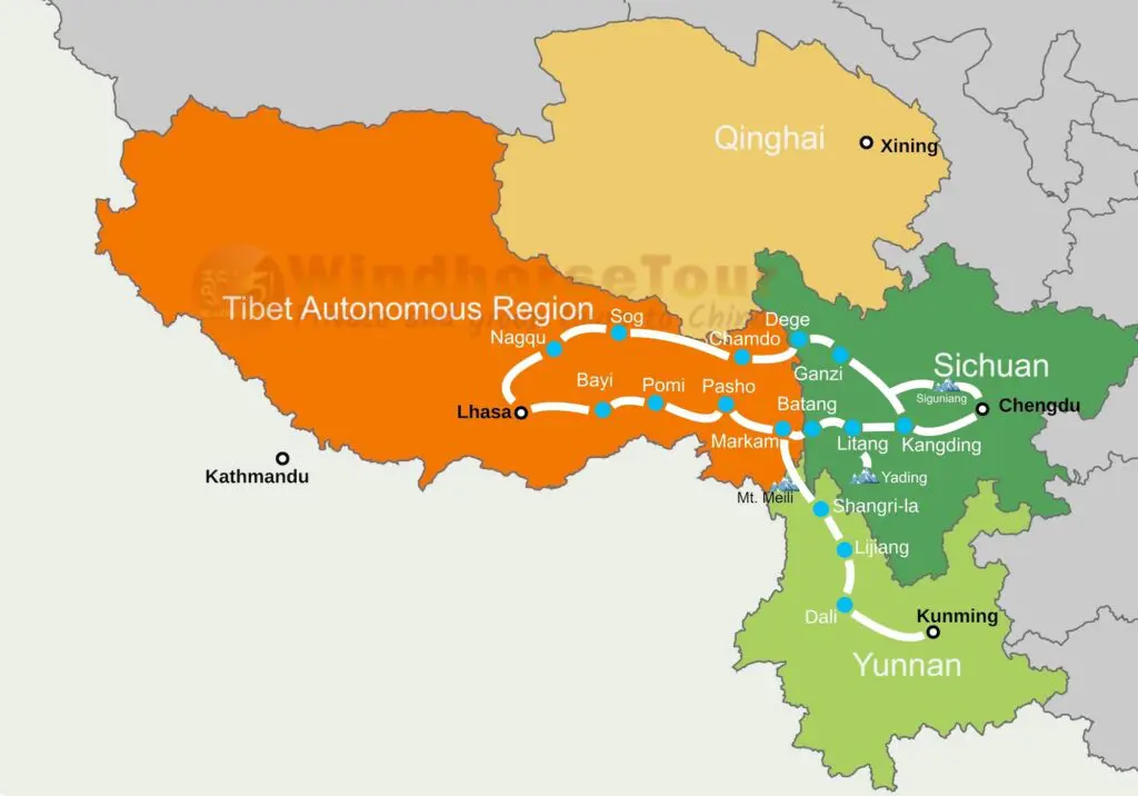
Table of Contents
Overview of the Major Highways from Sichuan and Yunnan to Tibet
There are four main overland routes to Tibet, from Sichuan, Yunnan, Qinghai, and Xinjiang.
Among them, the Sichuan–Tibet and Yunnan–Tibet Highways are by far the most beautiful and culturally rich, passing through the historical Kham Tibetan region, known for its monasteries, nomadic culture, and spectacular alpine scenery.
| Route | Road Code | From → To | Distance | Altitude Range | Travel Time | Main Features |
| Sichuan–Tibet Highway (Southern Route) | G318 | Chengdu → Kangding → Litang → Markham → Lhasa | 2,142 km | 500 m–5,130 m | 8–10 days | Glaciers, lakes, forests, and lush Nyingchi valleys |
| Sichuan–Tibet Highway (Northern Route) | G317 | Chengdu → Danba → Garze → Chamdo → Nagqu → Lhasa | 2,412 km | 500 m–5,089 m | 10-12 days | High grasslands, monasteries, and wild Kham landscapes |
| Yunnan–Tibet Highway | G214 + G318 | Kunming → Dali → Lijiang → Shangri-La → Markham → Lhasa | 2,200 km | 1,800 m–5,130 m | 7–12 days | Tea-Horse Road heritage, Meili Snow Mountain, river gorges |
Sichuan–Tibet Highway (G317 & G318)
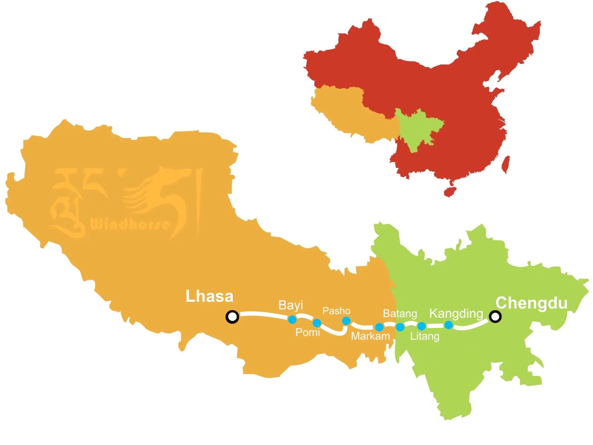
The Sichuan–Tibet Highway is one of China’s most spectacular overland routes, stretching over 2,100 km from Chengdu to Lhasa. Completed in the early 1950s, it was built with two parallel routes across the Kham region – the southern G318, known for its dramatic mountain scenery and accessible travel, and the northern G317, famed for its remote landscapes, rich monastic culture, and wild frontier atmosphere. Both routes reveal the breathtaking diversity of Tibet’s natural and cultural heritage.
Southern Route (G318) — China’s Most Beautiful Road

The Sichuan–Tibet Highway Southern Route (G318) is the most famous and scenic overland road to Lhasa, often celebrated as “China’s Most Beautiful Road.” Stretching from Chengdu to Lhasa, it crosses 14 high mountain passes and showcases western China’s most spectacular landscapes, from alpine meadows and glaciers to turquoise lakes and lush forests.
The journey begins in Chengdu and heads west through Ya’an and Luding to Kangding, the gateway to the Tibetan Plateau. A detour to Hailuogou Glacier can be arranged before reaching Kangding. From there, the road climbs over Zheduo Mountain Pass (4,298 m) into the Kham region, passing Xinduqiao, with an optional detour north to Tagong’s grasslands and monastery, before continuing to Yajiang and Litang, known as one of the world’s highest towns and famous for its annual Litang Horse Racing Festival in early August.
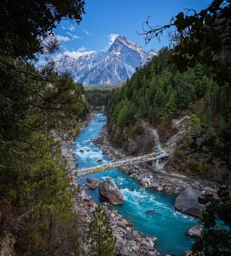
Before reaching Batang, travelers can take a rewarding side trip to Yading Nature Reserve, often called “the last pure land on our blue planet.” The highway then crosses into Tibet at Markham, continues over Dongda Pass (5,130 m), the highest point on the route, and winds through the famous 72 Nujiang Turns. The journey passes Ranwu Lake, Pomi, Nyingchi Bayi and Basum Tso, before finally arriving in Lhasa, the capital city of Tibet.
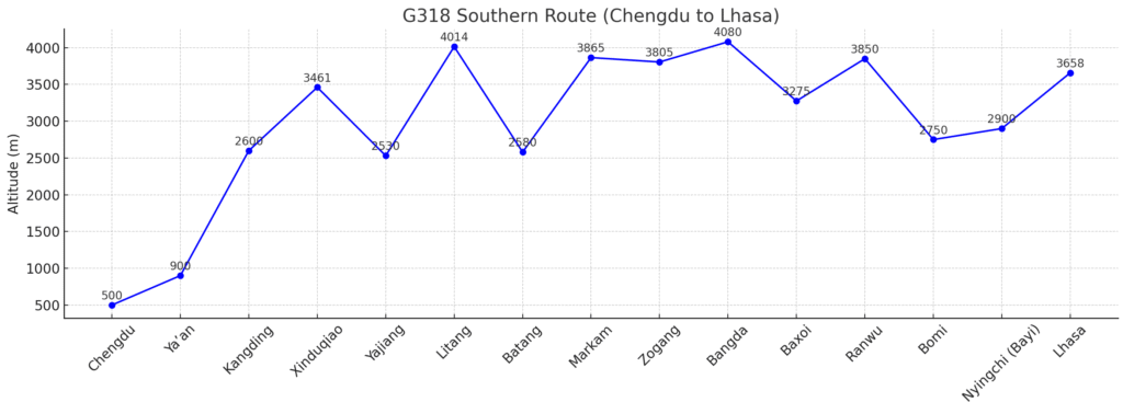
- Route: Chengdu – Kangding – Litang – Batang – Markham – Ranwu – Bomi – Nyingchi – Lhasa
- Distance: 2,142 km
- Highest Elevation: Around 5,130 meters at Dongda Mountain Pass
- Highlights: Alpine meadows, glaciers, turquoise lakes, and forested valleys.
- Why Go: This route offers the most dramatic scenery — from the Tagong grasslands and Litang Monastery to Ranwu Lake and Nyingchi’s lush forests.
- Highlights:
- Alpine meadows of Tagong and high-altitude town Litang
- Ranwu Lake and Laigu Glacier, turquoise waters beneath snow peaks
- Bomi forests and Nyingchi’s “Switzerland of Tibet” valleys
- Final descent through Mila Pass to Lhasa
Explore the full guide: Top Things to Do on the Sichuan–Tibet Highway Southern Route (G318)
Check the detailed itineraries of Chengdu to Lhasa overland tour along southern route G318:
11 days Classic Chengdu to Lhasa overland tour
14 days Chengdu to Lhasa Overland Tour via Daocheng Yading
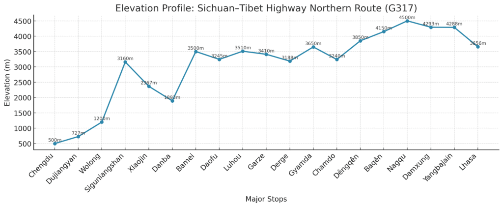
Northern Route (G317) — The Cultural Heart of Kham and Wild Frontier
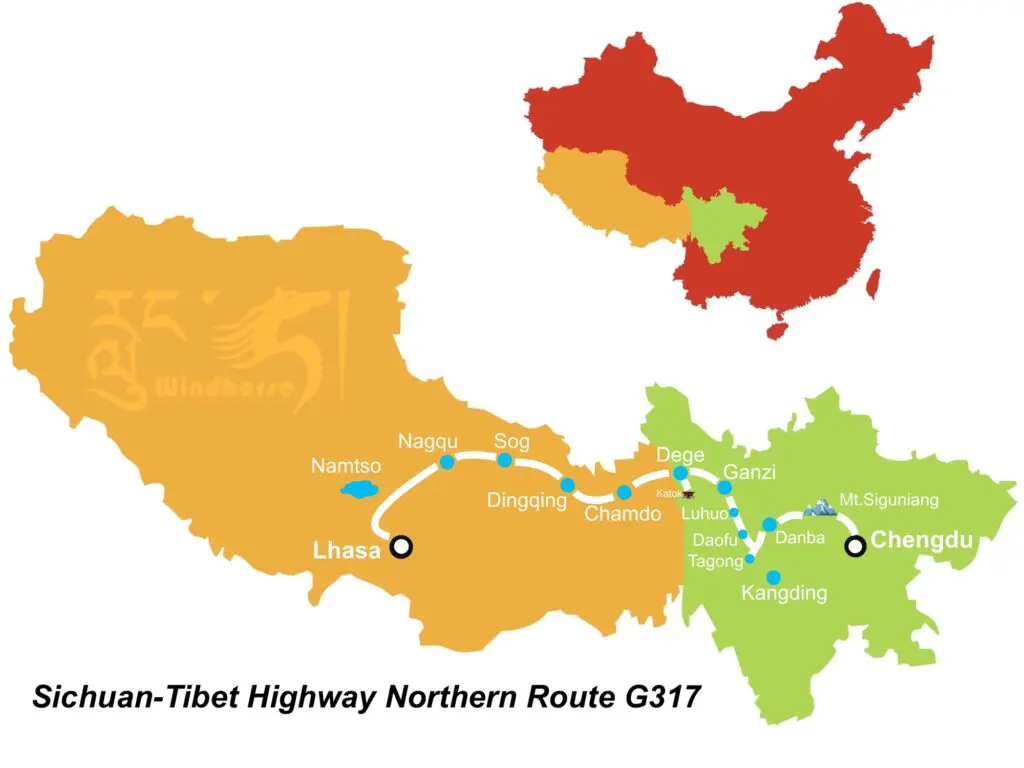
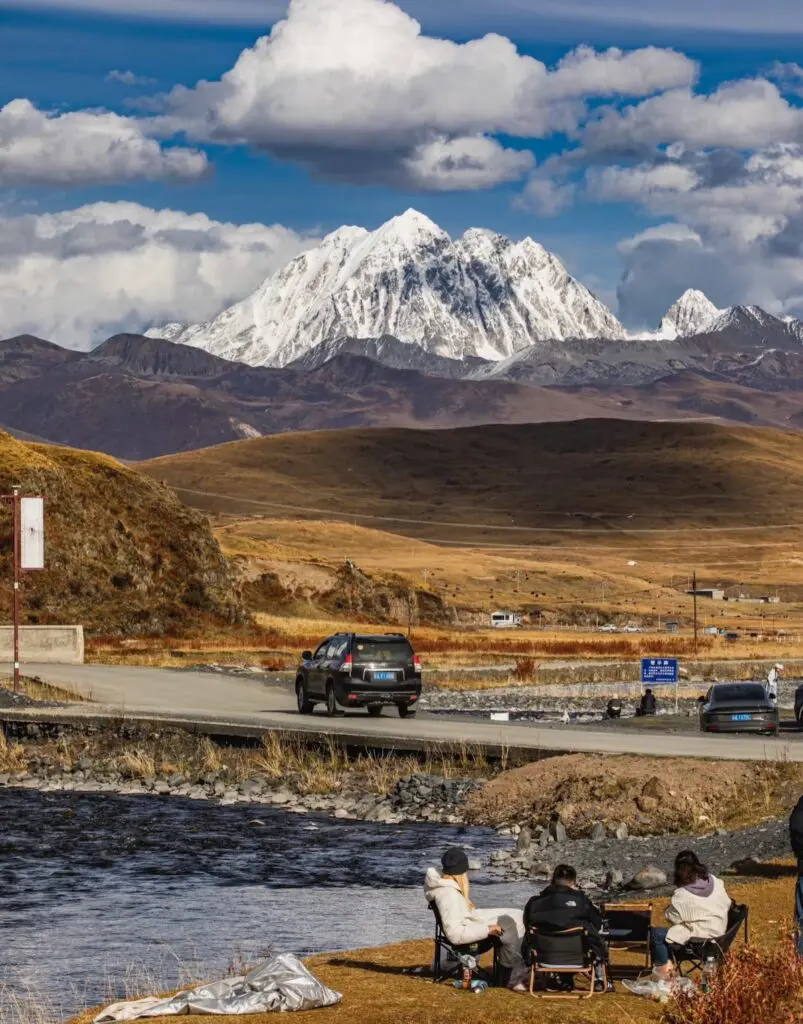
The Sichuan–Tibet Highway Northern Route (G317) runs roughly parallel to the Southern Route (G318) but follows a more northerly and higher path across the high plateaus and deep valleys of Kham Tibetan region, eventually joining the Beijing (Xining) to Lhasa highway at Nagqu before reaching Lhasa.
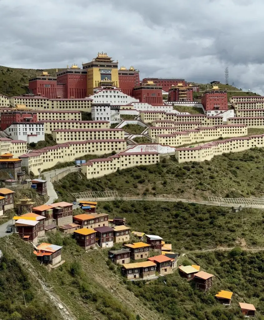
The official G317 route crosses the Aba and Garze Tibetan Autonomous Prefectures before entering Chamdo in eastern Tibet. It passes several important Tibetan Buddhist centers, including Sertar Larung Gar, one of the largest monastic institutes in the world, and Dege, home to the ancient Sutra Printing House. This route offers vast grasslands, rugged passes, and strong Tibetan monastic culture, more remote and less developed for tourism than the southern route G318.
However, due to the closure of Sertar Larung Gar to foreigners, we recommend an alternative route that diverges from the official G317 early on, Instead of heading north through Ma’erkang (Barkam) and Sertar, you will travel northwest from Chengdu via Mount Siguniang, Danba, Bamei, Daofu, Luhuo to Garze, where to rejoin the main Sichuan–Tibet Highway Northern Route (G317). This alternative route offers richer scenery, deeper cultural experiences, and better-developed tourism infrastructure, with a wider choice of hotels and dining options.
- Route: Chengdu – Mount Siguniang – Danba – Bamei – Luhuo – Garze – Dege – Chamdo – Nagqu – Lhasa
- Distance: Approx. 2,200 km
- Highest Elevation: Around 5,000 m
- Travel Time: 10-12 days (just depending on how many detours you would like to take)
- Highlights: Remote monasteries, Tibetan towns, vast grasslands, and the wild beauty of the Kham Tibetan region.
- Why Go: Higher and less traveled than the southern route, the G317 showcases authentic Tibetan culture, dramatic frontier scenery, and a true sense of exploration.
Highlights Along the Way:
- Mount Siguniang (Four Girls Mountain): Snow-capped peaks and alpine valleys ideal for trekking and photography.
- Danba Tibetan Villages: Visit Jiaju and Zhonglu — stone-towered villages often called the most beautiful in China.
- Tagong Monastery & Grasslands: Sacred Sakya monastery and broad meadows beneath Mount Yala (5,820 m).
- Garze & Luhuo: Traditional Kham towns surrounded by prayer-flagged ridges and centuries-old monasteries.
- Dege Printing House: One of the most revered cultural sites in Tibet, preserving woodblock Buddhist scriptures.
- Chamdo & Beyond: Cross the Jinsha River into Tibet proper, passing through monasteries and high passes toward Nagqu and Lhasa.
Explore the full guide: Top Things to Do on the Sichuan–Tibet Highway Northern Route (G317)
Check the detailed itinerary of Chengdu to Lhasa overland tour along northern route G317:
Yunnan–Tibet Highway (G214 + G318): The Ancient Tea-Horse Road of Cultural and Scenic Diversity
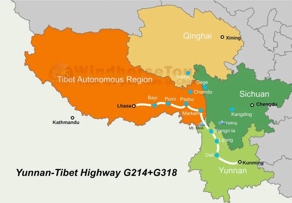
The Yunnan–Tibet Highway, combining G214 and G318, is another stunning overland route linking Kunming to Lhasa over about 2,200 km. Opened in 1974, it follows much of the ancient Tea-Horse Road, where tea from Yunnan was traded for Tibetan horses for centuries.
The Yunnan–Tibet Highway combines Yunnan’s colorful diversity with Tibet’s high-altitude grandeur.
Following the route of the historic Tea-Horse Road, the highway winds through vibrant towns, snow-capped mountains, and deep river gorges before joining the Sichuan–Tibet Highway (G318) at Markham. From there, it continues across eastern Tibet via Ranwu Lake, Bomi, and Nyingchi, eventually reaching Lhasa.
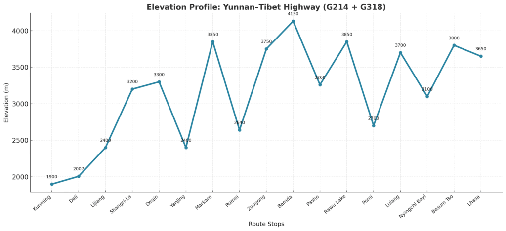
- Route: Kunming – Dali – Lijiang – Shangri-La – Deqin – Yanjing – Markham – Ranwu – Bomi – Nyingchi – Lhasa
- Distance: 2,200 km
- Highest Point: Dongda Mountain Pass (5,130 m) between Markham and Zuogong
- Travel Time: 7–12 days (depending on starting point — Kunming, Lijiang, or Shangri-La)
- Highlights: Yunnan’s ancient towns, alpine lakes, and deep gorges blending into Tibet’s snow peaks, glaciers, and holy sites such as Meili Snow Mountain and Ranwu Lake.
- Why Go: Following the historic Tea-Horse Road, this route combines Yunnan’s ethnic diversity and lush valleys with Tibet’s high-altitude beauty and spiritual heritage.

This highway passes through some of southwest China’s most iconic destinations:
- Dali: Explore the Old Town and sail on serene Erhai Lake.
- Lijiang: Visit Jade Dragon Snow Mountain and the traditional Naxi courtyards.
- Tiger Leaping Gorge and Shangri-La’s Songzanlin Monastery
- Shangri-La: A high-altitude paradise of temples, meadows, and snow peaks.
- Deqin & Meili Snow Mountain: Witness sunrise over the holy Kawagarbo Peak.
- Yanjing: See traditional salt pans before entering Tibet at Markham, where the route joins the Sichuan G318, continuing through Ranwu Lake, Bomi, and Nyingchi to Lhasa.
Check the detailed itinerary of Lijiang to Lhasa overland tour along Yunnan to Tibet highway:
Comparing the Routes: Which Sichuan–Tibet or Yunnan–Tibet Highway Should You Choose
| Feature | G318 – Southern Sichuan–Tibet Route | G317 – Northern Sichuan–Tibet Route | Yunnan–Tibet Route (G214 + G318) |
| Scenery | Most diverse — snow mountains, glaciers, alpine lakes, and highland grasslands like Tagong and Litang | Remote and wild — vast grasslands, rugged peaks, and deep valleys across the Kham Tibetan region | From Yunnan’s terraced valleys, gorges, and forests to Tibet’s alpine lakes, glaciers, and snow peaks along the G214 + G318 |
| Culture | Balanced mix of Han, Qiang, Khampa, and Tibetan influences | Strong Kham monastic culture, traditional Tibetan towns and nomadic life | Rich blend of Bai, Naxi, and Tibetan cultures rooted in the Ancient Tea-Horse Road |
| Road Condition | Best-maintained and most serviced route | Rougher, longer stretches with basic infrastructure | Generally smooth and well-paved, with continuous improvements |
| Altitude Change | Gradual ascent (≈ 500 m → 5,130 m at Dongda Pass) | Steeper gains (≈ 500 m → ~4,800–5,000 m) with multiple high passes | Gradual ascent (≈ 1,800 m in Yunnan → 5,130 m at Dongda Pass) |
| Best For | First-time visitors, photographers, and scenery lovers | Cultural adventurers seeking authentic Tibetan culture and heritage, nomadic traditions, and off-the-beaten-path adventures. | Nature and culture seekers wanting scenic diversity |
| Typical Duration | 8–10 days | 10–12 days | 7–12 days |
If you have extra time, you can combine the routes for a truly epic journey. Many travelers follow the southern G318 through Sichuan, then head south to Yading and Mount Meili before continuing along G214 to Markham, where the road meets G318 again on the way to Lhasa.
Others take the northern G317 across Sichuan and switch to G318 after entering Tibet.
For the adventurous, traveling to Tibet via G318 and returning via G317 creates a spectacular loop through some of western China’s most diverse and unforgettable landscapes.
Best Time to Travel on Sichuan/Yunan Tibet Highways
| Route | Best Months | Features |
| G318 (Southern Sichuan–Tibet) | May–June, September–October | Clear skies, open passes, colorful forests, and excellent road conditions |
| G317 (Northern Sichuan–Tibet) | June–September | Green grasslands, lively Tibetan festivals, and warmer weather across high plateaus |
| Yunnan–Tibet (G214 + G318) | May–June, September–October | Stable weather from Yunnan to Tibet, clear mountain views, and vivid autumn colors |
Avoid July–August, when heavy rainfall may cause landslides or temporary road closures in mountain areas or have 1-2 days extra days for a more flexible itinerary.
Best time for Sichuan–Tibet Highway Southern Route (G318)
The best months to travel the Sichuan–Tibet Highway southern route (G318) are May–June and September–October, when the weather is mild, skies are clear, and the high passes are free of snow. These seasons offer the best combination of comfort, scenery, and photography conditions.
July–August brings lush green meadows and wildflowers, but also heavier rainfall that can occasionally trigger landslides or affect road conditions.
Best time for Sichuan–Tibet Highway Northern Route(G317)
For the Sichuan Tibet Northern Route (G317), the ideal travel window is June–September. During this time, the vast grasslands of Kham are at their greenest, nomads are active on the plateau, and local festivals fill towns with color and music.
However, rain is more common in July and August, and some high mountain sections may experience fog or rougher road conditions.
Best time for Yunnan–Tibet Highway (G214 + G318)
The best time to travel the Yunnan–Tibet Highway is May–June and September–October, when the weather is stable from Yunnan’s low valleys to Tibet’s highlands. These months bring clear mountain views, comfortable temperatures, and colorful forests, especially around Shangri-La, Deqin, and Nyingchi.
July–August remains beautiful and vibrant, but expect more rain in Yunnan and occasional fog or road delays on the Tibetan side.
General Travel Tips for Sichuan and Yunnan Highways
- Altitude: Both the Sichuan–Tibet and Yunnan–Tibet Highways climb dramatically from low valleys to the high Tibetan Plateau. The journey starts at around 500 m in Chengdu or 1,800 m in Kunming, and rises to over 5,000 m at the highest passes such as Dongda Pass and Mila Pass. To prevent altitude sickness, ascend gradually and schedule acclimatization stops in places like Kangding, Yajiang, or Shangri-La. Stay hydrated, avoid overexertion in the first few days, and get enough rest before heading higher.
- Pack for All Seasons: These routes cover a vast range of climates, from the humid lowlands of Sichuan’s Chengdu Basin to the mild highlands of Yunnan and the cold, dry air of the Tibetan Plateau. Pack layered clothing to handle these changes, including a fleece or down jacket, windproof outer shell, and thermal base layers for high-altitude nights. Bring sunscreen, sunglasses, lip balm, and a wide-brimmed hat to guard against strong UV rays at elevation. Comfortable walking shoes are ideal for monastery visits and short hikes, while power banks come in handy since charging points can be limited in remote regions.
- Road and Driving Conditions: Expect long, winding mountain drives with steep ascents, hairpin turns, and changing weather. While most main highways are well-maintained, some sections can be rough or bumpy due to heavy truck traffic, road repairs, or ongoing railway construction. After rain or snow, conditions may worsen quickly, and occasional landslides or temporary closures can occur during the rainy season (July–August). For a safer and smoother journey across these high mountain routes, it’s best to book your tour with a reliable travel agency like WindhorseTour, which will provide an experienced local driver familiar with the terrain and local conditions.
- Tibet Travel Permits: While the Sichuan and Yunnan sections can be traveled on your own, once you enter the Tibet Autonomous Region (TAR), all foreign travelers must join an organized tour arranged by a licensed travel agency such as WindhorseTour. A Tibet Travel Permit (TTP) is required to cross the border into Tibet and is checked at multiple points along the way. Travelers must also be accompanied by a Tibetan guide, driver, and private vehicle within the TAR. Keep in mind that some areas, including Chamdo and Nagqu, may occasionally close to foreigners, so always check the latest regulations before traveling.
- Respect Local Culture: Tibetan Buddhism and regional traditions are deeply rooted along both routes. When visiting monasteries, dress modestly, speak quietly, and walk clockwise around stupas and prayer walls. Always ask permission before photographing monks or locals, and avoid touching sacred objects or prayer flags. Showing genuine curiosity and respect helps foster meaningful cultural exchanges along your journey.
- Flexibility: Weather and road conditions in the mountains can change quickly, especially during the rainy season (July–August). It’s wise to allow 1–2 buffer days in your itinerary in case of unexpected delays. Building flexibility into your schedule ensures you can travel safely and still enjoy every highlight along the route.
- Photography and Timing: For the best light and colors, plan photography sessions in the morning and late afternoon, when the landscapes glow under soft sunlight.
Conclusion: Which Highway Should You Choose
Whether you take the Sichuan-Tibet southern G318, the northern G317, or the Yunnan–Tibet G214+G318, each road to Lhasa offers its own blend of challenge, culture, and breathtaking scenery.
The Sichuan–Tibet Highway (G318) offers diverse landscapes and smooth travel through high mountains, alpine lakes, and deep valleys, while the G317 captures the wild essence of the Kham region with its glaciers, remote monasteries, and vast grasslands. The Yunnan–Tibet Highway (G214 + G318) adds a gentler cultural transition, blending Yunnan’s tea terraces and ethnic villages with Tibet’s sacred peaks and spiritual serenity.
No matter where you begin, Chengdu, Shangri-La, or Kunming, these highways promise one of the most extraordinary overland adventures on Earth.
For practical travel tips, routes, and permits for Kham Tibetan region, see our Ultimate Kham Tibet Travel Guide.
Related tours


Take a Chengdu to Lhasa overland tour via Daocheng Yading along the Sichuan–Tibet Highway Southern Route (G318). Travel through Tagong Grasslands, Litang, Yading Nature Reserve, Ranwu Lake, Midui Glacier, Lulang Forest, and Draksum-tso before reaching Lhasa.


Travel from Chengdu to Lhasa along the Sichuan–Tibet Highway (G318) and Yunnan–Tibet Highway (G214), with detours to Daocheng Yading and Mount Meili. Explore Mount Siguniang, Danba Tibetan villages, monasteries, holy lakes, glaciers, and the dramatic landscapes of Kham regions in Sichuan, Yunnan, and Tibet.


Set out on an unforgettable 11-day Chengdu to Lhasa overland tour along the Sichuan–Tibet Highway (G318). Cross high passes, vast grasslands, glaciers, and sacred lakes while experiencing yourself in Kham culture and the dramatic landscapes of eastern Tibet.
Comments
We (my wife and I) would like to enquire about doing a loop via G318 and returning via G317. How many days will this take and the cost per person. In addition when will be the best months to do this loop. Thank you.
Dear SC Tan,
Thank you for your inquiry. This is Jenny from WindhorseTour.
We can certainly assist with arranging this trip
I have prepared a detailed itinerary and quotation for your reference and have shared it with you via email. Please take a look and feel free to share any thoughts or comments.
I look forward to helping you plan an unforgettable trip!
Best regards,
Jenny