The Map of Tibet - Learn Where is Tibet
This article 'Where is Tibet' aims to inform you about the location of Tibet through maps. It provides maps of Tibet that show its position in the world, Asia, and within China. This useful Tibet Travel Guide showcases maps of Tibet Autonomous Region's six prefectures, highlighting key rivers, lakes, and mountains.
Transportation systems including air, railways and highways are covered. Popular attractions and great trekking routes in Tibet are also shown in specific Tibet maps. Plus some interesting facts about Tibetan people, their food, economy and beyond.
Tibet on A Map - Where Is Tibet

Known as the "Roof of the World", Tibet is remote, unique and fascinating to all. It boasts a distinct culture and breathtaking scenery. Not to mention the highest mountain in the world - Mount Everest at 8,848 m. (29,029 ft.), along with other 10 peaks over 8,000 m. You may wonder where is Tibet on map, this mysterious land? What is the most attracting places to visit? To put those information in an easy to swallow; here is an essential map of Tibet and beyond.
Map of Tibet and China
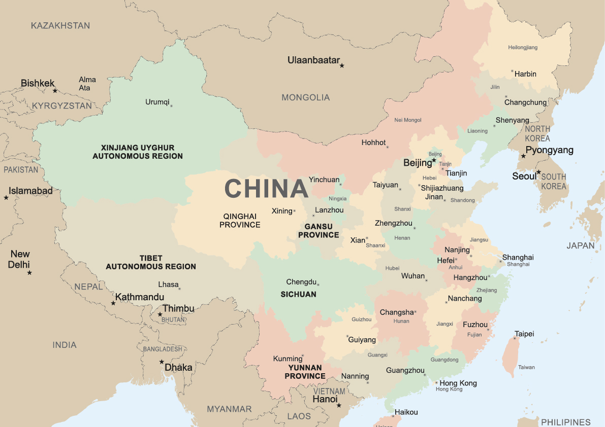
Tibet is located at the heart of Asia as is shown in the Tibet map, with Nepal, Bhutan, India, Sikkim to the south and west; China's four provinces to the north, east and southeast, namely Xinjiang, Qinghai, Sichuan and Yunnan.Today, Tibet is largely referred to as the Tibet Autonomous Region of China (TAR, Xizang in Chinese).
The TAR was established in 1965 by the People's Republic of China.Traditionally, Tibetans also live in regions like the western Sichuan, southern Gansu, and northern Yunnan. Some also live in countries like Nepal and India. The Tibetan population in TAR and other provinces of China is 6.4 million in 2013.
Tibet is the highest region on earth, which covers a land of 1.2 million sq. km., with an average elevation of 4,000 m. (13,123 ft.) Its height, together with the grand Himalayan region on its south, have deterred frequent communication with the outside world, thereby believed to have contributed to Tibet's distinctiveness.
The Geographical Layout Map of Tibet

This Tibet map is from Wikipedia, showing the geographic layout of the Tibet Plateau. As you can see the northern part of Tibet are mostly plateau areas with surrounding mountains and basins. It is the main pastry zone of nomads. Southern Tibet is abundant in valleys, providing limited arable lands for agriculture. Its eastern part is marked by the great Himalayan Region and Hengduan Region (mostly in Sichuan province). Snow-capped peaks, dense forests in the shoulders, and farmlands in the feet of mountains are all packed for one glimpse.
The Tibetan Plateau Rivers
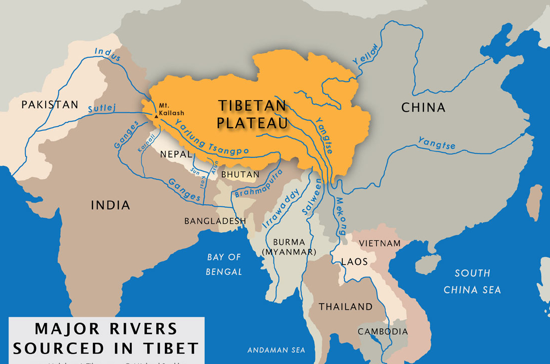
The Tibet Plateau is the birthplace of several major rivers, including Yangtze river and Yellow river in China, as well as Yarlung Tsangpo, Mekong and Salween River in Southeast Asian countries like Burma. It is crystal clear in the map made by Michael Buckley.
Map of Tibet Autonomous Region

The TAR has six prefectures besides its capital city Lhasa (prefecture-level city), namely Ngari, Nagqu, Chamdo, Shannan, Shigatse, Nyingchi Prefecture. Most Tibetans lives in the eastern and southern Tibet. Most dense population are observed in and around big cities like Lhasa, Shigatse and Nyingchi. The rest of Tibet is largely sparsely populated. Increasing number of Han and Hui people have been observed there in recent two decades.
Tibet Transportation
Lhasa (3,650 m.), the capital of Tibet, is the largest city in this region. The second large city is Shigatse. Transportation system connecting China and Tibet are modernized by airlines and railways, alongside with highways.
Lhasa to Kathmandu airline is the only international flight to Tibet. There are several domestic flights though, from Beijing, Chengdu, Chongqing, Kunming etc. The Lhasa Gonggar Airport is the main airport serving Tibet, 60 km. ( 37 mi.) from Lhasa.
Map of Qinghai - Tibet Railway
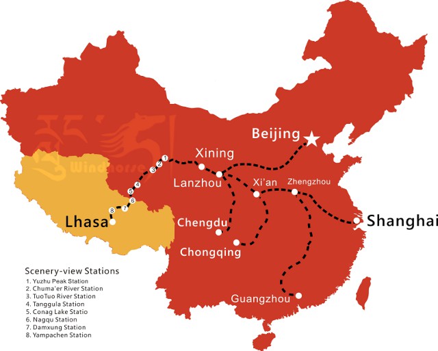
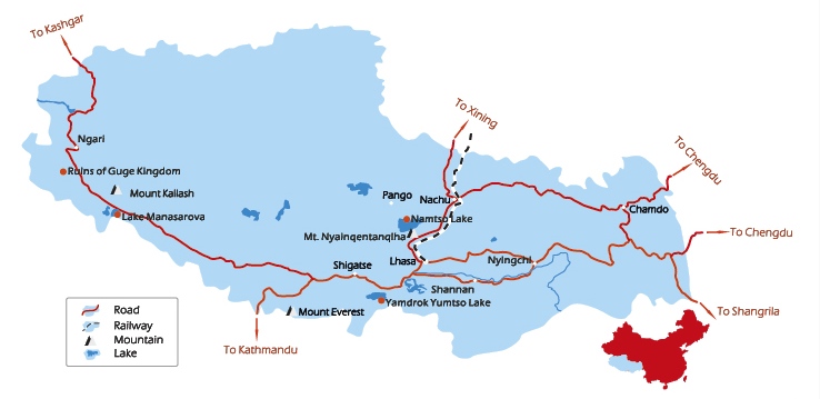
Tibet is connected to China and Nepal by highways. Currently there are three major highways reaching Lhasa from China's Sichuan, Yunnan and Xinjiang provinces. All those roads are well maintained in recent years. The Nepal-China friendship highway connects Lhasa and Kathmandu. A 4WD is usually needed on these highways.
Tibet Key Lakes and Mountains
Tibet is a land full of intoxicating lakes and magnificent mountains. Each one of them is surrounded by tales and mystery. The three holy lakes of Tibet includes Namtso Lake, Yamdrok Lake and Manasarvar Lake. The most noted mountains in Tibet are Mt. Kailash, Mt. Everest and Mt. Namche Barwa.
Related tours
Where is Tibet's Most Popular Attractions
Assorted by geographical location, popular attractions in eastern Tibet include the Tibetan Switzerland Nyingchi, Yurlung Tsangpo Grand Valley (the deepest valley in the world), and Rawok-tso. The Western Tibet is signified by wild-west views.
The holy Mount Kailash (6638 m.) is a top choice for most people planning to visit this region. Chances are that you will bump into Tibetan nomads on their pilgrim path or simply herding their yaks and sheep. They may sing aloud with pretty raw voices.
Adding to the charm is one of the three holy lake of Tibet, the Manasarvar Lake. Plus the mysterious ruins of Guge Kingdom for you to explore.
Map of Nepal China Friendship Highway

There is a lot to see along the Nepal China friendship highway. To name just a few, Tashilhunpo Monastery in Shigatse, Yamdrok Lake - one of the three holy lakes, around 110 km. (68 mi.)from Lhasa, Sakya Monastery - approximately 180km. (112 mi.) from Shigatse, plus the one and only unsurpassed Mount Everest.
Map of Lhasa City Attraction
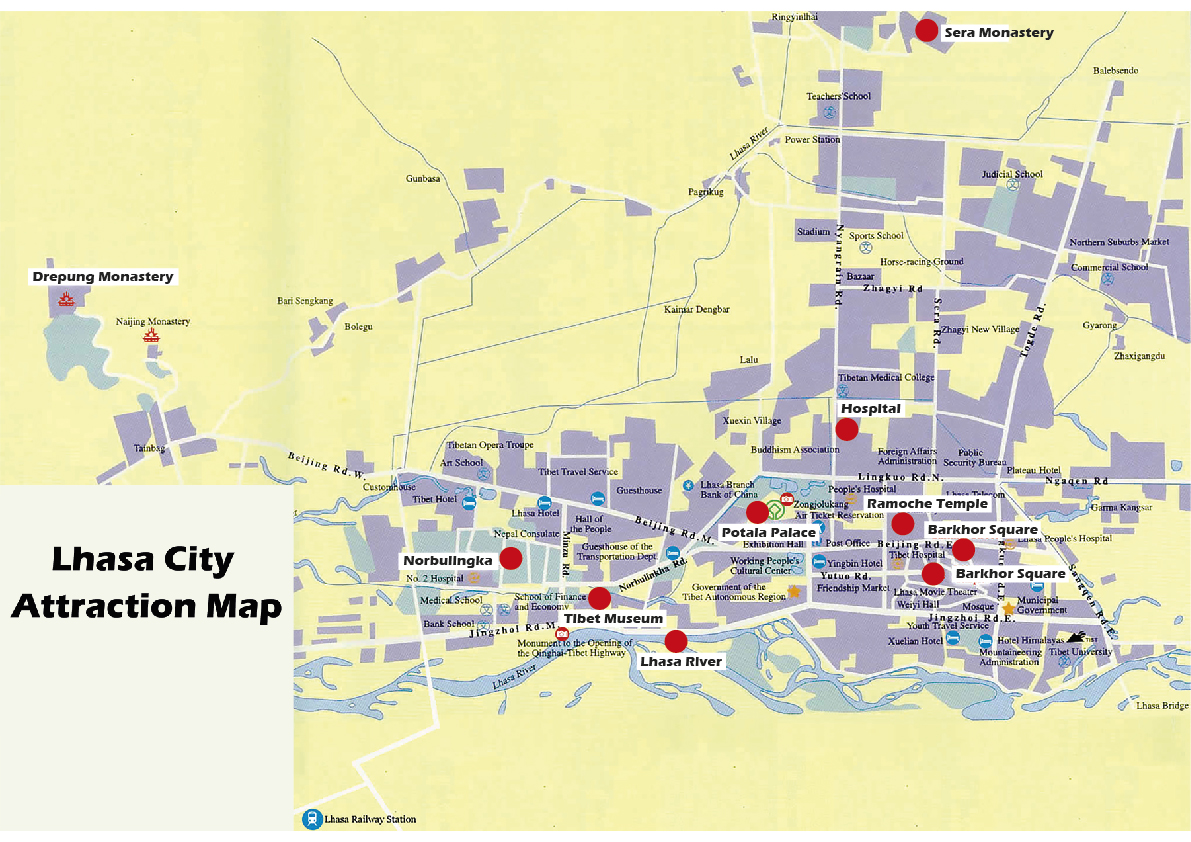
Lhasa is known as the Land of Gods and the City of Sunshine. It is the largest city in TAR. The city will never fail you even though it is on the way toward modernization.
Potala Palace, the former residence of the spiritual leaders of Tibetans including Dali Lama and Panchen Lama, is the landmark of Lhasa. It is located at downtown Lhasa, accessible only by tickets.
The Barkhor square is famous for two reasons: firstly, it is a bazaar packed with Tibetans bargaining for daily necessities and more; secondly, it is a noted pilgrimage path to the Jokhang Temple (the spiritual center of Tibet), around 1 km. from the Potala Palace.
Ramoche Temple, the sister temple to the Jokhang, is also around 1 km from the Potala Palace. Other temples and monasteries includes the Sera Monastery, the Norbulingka (it means "baby's garden in Titetan", the summer palace of the Dali Lamas), Tibet Museum and more.
Attractions Around Lhasa
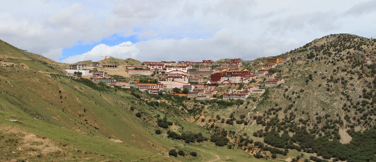
Attractions around Lhasa include the Yamdrok Lake (Along the Friendship Highway), Namtso Lake 240 km. northwest of Lhasa, Samye Monastery (the first Buddihst temple in Tibet), and Ganden Monastery. Tibet has many Pilgrim paths, or Kora (circumambulation). The most popular ones include Mt. Kailash Kora, which takes around 3 days, Ganden monastery and the Barkhor Kora.
Map of Great Trekking Routes in Tibet
Map of Ganden-Samye Trekking Route
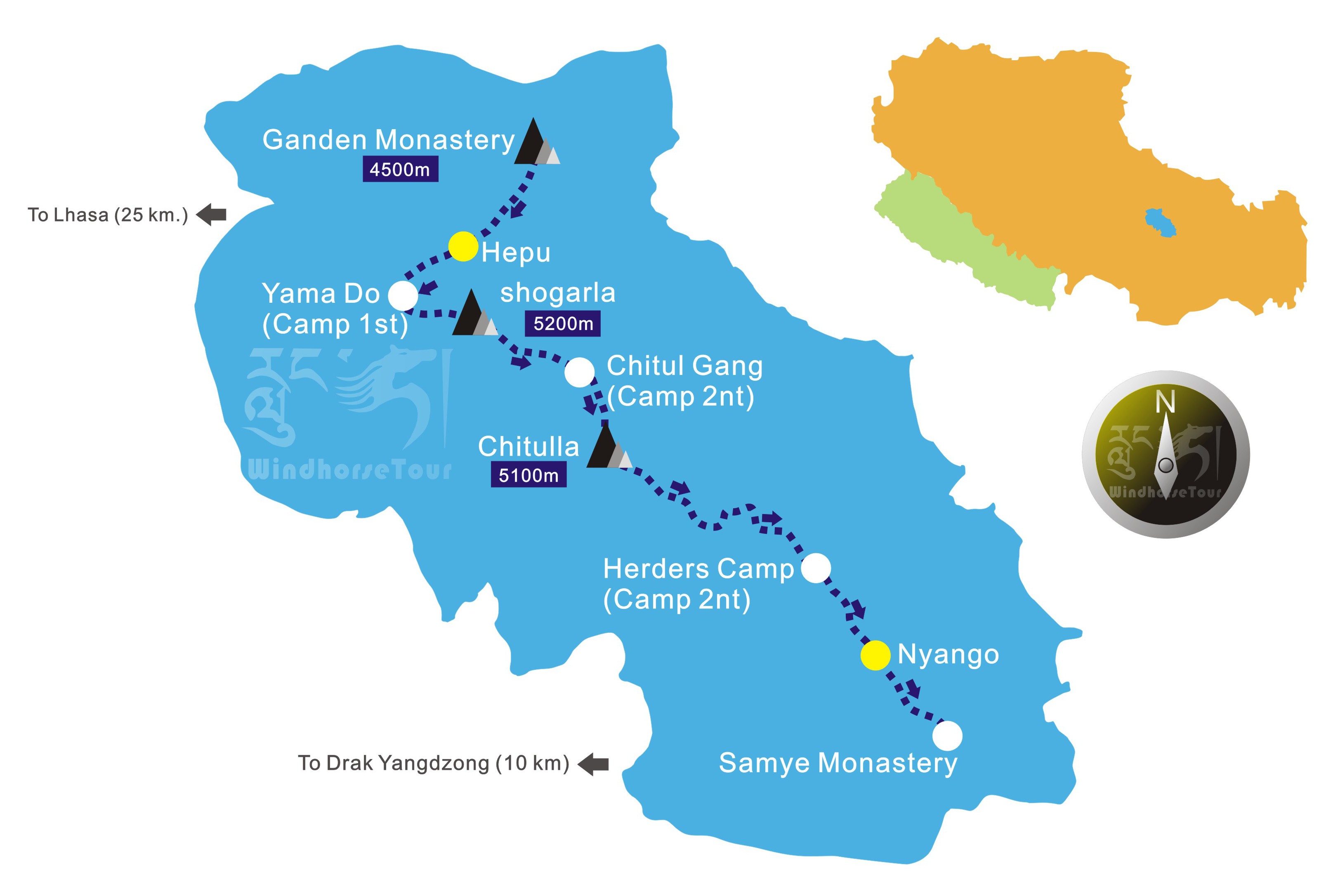
The Ganden to Samye trekking is the most popular route of its kind in Tibet. It allows visitors to take a closer look at the amazing natural scenery as well as experience the high plateau Tibetan religious culture.
As is shown in the trekking map of Ganden-Samye, the highest point in this route is Shogarla at 5200 m.(17,060 ft.), which might be proved challenging to many. High altitude sickness is what you should watch out for.
Map of Mount Kailash Trekking

The Mount Kailash trekking route will fully immerse you into the ancient culture the Tibet Buddhism Bon. The pilgrim's path around Mount Kailash, Asia's most sacred mountain, is age-old.
With a 5,630 m. (18, 471 ft.) to pass, this Kora is a true test of your mind and soul. The Mount Kailash map illustrates the main stops for a 2-3 day trekking. Darchen, Dirapuk, and Dzultul Puk, all centering around the holy Mount Kailash.
Map of Mount Everest Trekking
Mount Everest is no longer preserved for hardy backpackers nowadays. It is the dream destination for anyone who want to get an unsurpassed view of the Mt. Everest. Starting from Old Tingri, you will get closer and closer to the northern face of mighty Mount Everest. A view from Rombuk Monastery at the end of the trekking compensates all your efforts in this extraordinary journey.
More Information You Need to Know About Tibet
Appearance of Tibetan People
Given the high altitude, people in this region are heavily exposed to sunshine. They usually have dark skin and flush in their faces. They wear long clothes made from wool and yak hair. Long hair and braids are commonly seen in men and women, especially in small towns and villages.
Interesting Facts about Tibetan People:
The Tibetan Plateau is the traditional habitats of the Tibetan people for thousands of years. Their legend has it that they are the decedents of macaque monkeys.
The Tibetans break down into several major groups as people from Amdo, Kham, and U-Tsang, whose languages are of the same origin but mutually unintelligible. They have been sharing this land with some other ethnic groups such as Monpas, Lhobas, and Qiang.
The Monpas and Lhobas used to be referred to as barbarian by Tibetans, as they have very strange eating habbits. For example, they drink the marrow of cattle directly; they eat snakes and frogs. They largely took residence in sparsely populated mountainous regions and woods in southeastern Tibet. The staple food of Tibetans are roasted barley (tsampa), yak meat and butter tea.
Religion of Tibet
The predominant religion in Tibet is Buddhism, which plays an essential part in shaping the culture of Tibet. It was brought to Tibet from India in the 7 th century A.D.. Tibetans are believed to be the most pious followers of Lord Buddha.
Weather of Tibet
The annual average temperature of Tibet is 8 C (46.4 F.). The weather in most of Tibet is dry and cold in winter save the southeast region bordering India. Summer is agreeable, and other seasons are chilly. Temperature during day and night differs greatly.
Economy of Tibet
The economic development of Tibet is mainly contributed by its agro-pastorial sector and its tourism industry. Tibet nomads herd their yaks and cattle around Tibet's plateau grasslands, eking for a living. Barley and buckwheat are the main crops grown. The main income from tourism is by selling hand crafts which are tax exempted. Many Tibetans become tourist guides, porters and mountaineers.
Map of Tibet Seen From Space
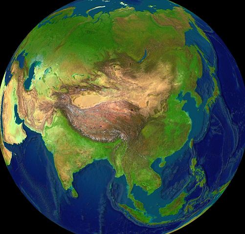
These Maps are the Atlas of Tibet and can provide you with clear ideas in terms of where is Tibet - its location in the world, Asia as well as in China.Great attractions in Tibet are listed in specific Tibet maps. Popular trekking routes with easy to catch maps are also covered in this article.
Tibet is no longer a remote dream place that denies your access. With awe-inspiring Buddhist monasteries and breathtaking scenery, many Tibet Tours beckons every traveler to come and create unmatched memories of a life time.
Sipping yak butter tea under the gorgeous sunshine of Lhasa while observing the daily routine of Tibetans allows you to embark on a spiritual journey, because Tibet Tibet is a life-changing experience.Your Tibet awaits!
Start Your Tibet Exploration with Us - Your Interest and Our Expert Knowledge Perfect Together!


Comments
8 days Itinerary if eastern tibet
In reply to 8days Itinerary if eastern… by Moses ong (not verified)
Dear Moses ong,
Thank you for your inquiry! I'm Victoria from WindhorseTour, and I'm delighted to assist you in planning your travel.
Considering you are looking for an 8-day trip to Eastern Tibet, I would recommed our 9 days Lhasa Nyingchi Tour to Ranwu Lake for you to review. Please advise if it meets your requirements, or if there are any destinations or attractions you would prefer to include in your itinerary.
To provide you with the most accurate information, could you please provide me with a bit more detail? Specifically, let me know:
- Your Traveling Time: It's important to understand your preferred traveling period, as you may be aware, the tour cost varies from season to season, even month to month.
- Number of Travelers: It would be helpful to know how many people will be joining the trip. As for our private tours, the tour cost for each person varies based on your group size.
- Accommodation Preferences: Are you looking for standard hotels inlcuding 3-star, 4-star, 5-star, or any specific type of accommodation?
We're looking forward to making your travel experience memorable and filled with the local charm of China and beyond. If you have any specific preferences or requests, please feel free to share them with us. Safe travels!
Best regards,
Victoria
We are a group of 3 Spanish people who are considering to visit Tibet during the third week of July 2016. Our trip could start in Chengdu and it would include the following items
- Train or plane from Chengdu to Lhasa and return
- Hotel 7 days in Lhasa
- Visit the main tourist places in Lhasa and surroundings
We would consider also transport Chengdu-Lhasa and a return air ticket from Lhasa to Guangzhou, Shenzhen or Hong Kong instead of coming back to Chengdu
Looking forward your answer
Best regards
Miguel Camacho and friends
In reply to Visiting Tibet next July by miguel camacho (not verified)
Hi Miguel,
Thanks for your inquiry.This is Anita from WindhorseTour.
I have sent two proposals with quotation to you for your reference. Please kindly check your email for more details, and feel free to contact me for any questions. Look forward to hearing from you soon.
Best Regards,
Anita